My GIS Projects

Explore a collection of interactive web maps and spatial analysis solutions, showcasing expertise in Geographic Information Systems and innovative data visualization.
Animated Inca Trail to Machu Picchu (3D)

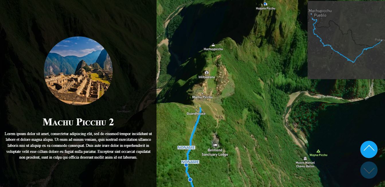
This is a 3D visualization of the Inca trail to Machu Picchu. There are many waypoints and each one is presented through a left panel showing its related info. User can scroll up/down to fly through waypoints, reaching at the end the Machu Picchu site

Read More Visit Site
Interactive Tree Mapping System for England Heritage Project - WIX -

Developed a comprehensive interactive mapping solution with 40+ county maps and national overview for an England heritage tree project.Built with Mapbox GL JS and connected to Google Sheets for dynamic data management. Features include custom tree/acorn icons, smart label positioning, mobile-responsive design, click-to-navigate county links, neighboring county navigation, zoom-adaptive layers, and minimap overview.Seamlessly integrated into […]

Read More Visit Site
Resort Walkable Path Network Mapping & Navigation Graph System

Created a comprehensive walkable path network for a resort property with 200+ rooms and 40+ destinations. Mapped all walkways, hallways, and outdoor paths using QGIS with georeferenced tiles.Developed navigation graph with 300+ edges and intersection nodes, categorized by type (walkway, corridor, stairs, elevator).Implemented accessibility routing, floor transitions, and bidirectional connections. Delivered interactive web visualization for […]

Read More
3D Interactive Web Map - Bubble.io - 3D Models integration - Threebox

3D Interactive Web Map with 3D buildings built with Google Sketchup. Libraries used: - ThreeboxJS & Mapbox GL JS

Read More Visit Site
Squarespace - Interactive Web Map - Real Estate Project

Interactive web maps development for a real estate company based in North Carolina. Around 18 maps for all NC cities, with all amenities (Schools/Hospitals/Parks etc.).

Read More Visit Site
WP Website - VOTRE Plombier - Interactive Map & Listing

A project integrating an interactive Mapbox web map for plumbers across Belgium. The site includes a detailed plumbers listing, a thumbs-up review system, and messaging between clients and plumbers via the Better Messages plugin.It uses Advanced Custom Fields (ACF) and WP Mail SMTP for custom fields and email management, while Ultimate Member manages user profiles […]

Read More
Djibouti Telecom - Interactive Web Map - Network Cables

Showcasing Marine Network Cables for Djibouti Telecom website. Built with Mapbox GL JS

Read More Visit Site
WP- Web Interactive Map - Parking Lots in Pensacola (Florida, USA)

Interactive web map for Pensacola Parking website + Website design using Elementor

Read More Visit Site
WP - SOLO Woman Interactive Web Map (Pin Your Location)

Developed a comprehensive interactive mapping solution for SOLO Woman community platform.Built custom MapBox integration with real-time location pinning, animated markers, and advanced filtering system. Features include WPForms integration, user role-based visibility, inspirational quote carousel, and mobile-responsive design.Created dynamic filter panels with color-coded categories and performance-optimized animations. Delivered engaging community visualization tool that transforms static listings […]

Read More Visit Site
Interactive Global Idea-Sharing Platform: Location-Based Social Map

Developed an interactive web map application connecting users worldwide through location-based sharing. Integrated Mapbox GL JS with Bubble.io to create a platform where users can register, have their location automatically saved and displayed on a global map, and share ideas.Features include secure authentication, real-time geolocation mapping, comprehensive profile management (photos, bio, Instagram links), and an […]

Read More Visit Site
1 2 3 5